Le Banchet
Arlebosc
Le Banchet
Hard
2h30
24,1km
+923m
-927m
Embed this item to access it offline
8 points of interest
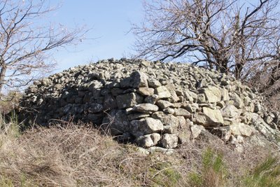
Chirat bâti par les paysans - Ardèche Hermitage Tourisme  Small patrimony
Farmer builders
At the hamlet called Les Morfins you can see how stone is a predominance in this landscape shaped by agriculture. The heaps of stones called "Clapas" or more locally "Chirat" didn’t come from the album, with a marked Irish influence, « Marchand de Cailloux » by the French singer Renaud , they were quite simply stones piled up by farmers on the edge of fields after being dug out for other uses and also to make the land more easy to work on. They are living proof of a rural civilisation that “tamed” water and stone and add to a stone architecture that the decline of agriculture has somehow made us forget. We cannot remain indifferent to the labour of these « farmer builders » who stone after stone built terraces or « chalets ». And there efforts did not stop there as they also built walls, enclosures to protect vegetable plots, small outbuildings, wells and other fountain vaults, steps, huts…. “graveliers » is the name they gave to small huts made of drystone, covered with vine shoots and used to shelter farmers and for storing tools and crops. Information source : "Paysans bâtisseurs, paysages de pierres, paysages de vie", association Histoire et Patrimoine, 2001.
 Panorama
Viewing point
Viewing point overlooking the village of Bozas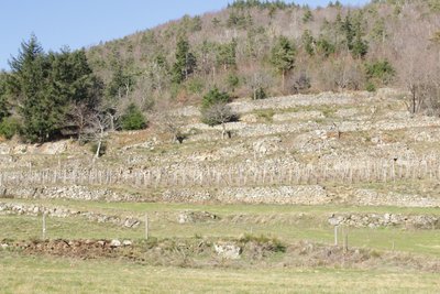
Murs des terrasses - Ardèche Hermitage Tourisme Small patrimonyChalets
If ever you hear a native of Ardèche mention the words « chalets », « faisses » or even « chambas » he (she) isn’t talking about the names of birds, just describing the so familiar landscape ! It definitely isn’t an easy task being a farmer on such steep slopes but it takes more than that to discourage the people from round here. And that is how Mankind came to shape the landscape making it more possible to work on. In order to increase the amount of land for growing, he decided to build the dry-stone wall terraces you can see, spreading across the slopes. These retaining walls were also used to hold water tanks, very handy on granitic well-drained soils !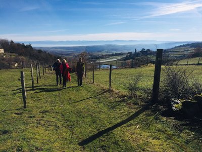
Point de vue sur les Alpes - Ardèche Hermitage Tourisme PanoramaViewing point
Beautiful views of the French Alps. Flora
FloraThe chestnut tree. Evidence of another era ?
Here and there old chestnut trees tower amongst the forest vegetation.They often highlight evidence that new trees have taken over old plots of chestnut production. Chestnut groves have indeed undergone an important decline over the last few decades. The species has been particularly affected by two sorts of fungus : phytophteria and canker. At its peak, at the end of the XlXth century, chestnut groves covered over 60000 hectares of land, twice the amount compared to today. The chestnut was at that time a basic food product for the inhabitants of Ardèche. Even though it is not the case nowadays, it is still popular and the many products made from the fruit are well worth trying. How about a little Occitan dialect : Pin de toun grand, chastagni de toun payre, vigna de tu !(your grandfather’s pine, your father’s chestnut, your vine !), A good pine tree needs 70 years to grow, the chestnut tree needs 25 years and the vine only takes 2. A good farmer plants for his grandchildren, his son … and himself !
Le Crestet
Le Crestet is a good example of a typical street village due to its uneven topography. The village appears in written works from the Middle Ages as texts about the church “Cresta”, dating back to 1164 have been found. The village developed thanks to lease agreements installed by Philippe le Bel in the village of Boucieu le Roi at the beginning of the XlVth century. As it was situated on the road going from Tournon to Lamastre, le Crestet was a stretegic position for travellers for a stopover. If you are in the area don’t miss seeing the church and especially the plague cross. One of the rare examples still in existence today and dating back to XVlth century. If you look closely you can distinguish what could have been buboes (infected skin swellings)caused by plague. Do you think it could have been erected as a thank you for some sort of protection or simply close to a cemetery of plague victims ? The miracle is in the fact that it can still be seen today !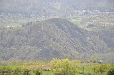
Vue du rocher de la Pierre qui vire - Ardèche Hermitage Tourisme  Geology
La Pierre qui vire viewing point
As if hanging from the sky and standing out in contrast with the landscape, the rock offers a spectacular sight. It hasn’t always been that way. The boulder is in fact the remains of a unique rock accumulation exposed by erosion. Water, making its way through gaps, shattered the rock during winter frosts. This particular block being harder and more compact therefore remained in one piece and once out in the open looks like a giant came and placed it here. It is said that the rock turns round on itself every hundred years making it impossible to know for certain when the last time was…. Just have to wait and watch out for the next time !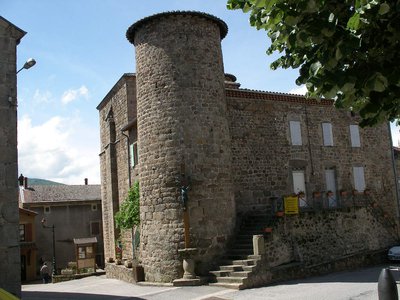
Vue extérieure du château - Ardèche Hermitage Tourisme The château of arlebosc
In the centre of the village you can see the old medieval château no doubt dating back to Xlllth century. Destroyed and in ruins it was rebuilt or made bigger several times and is a definite characteristic evidence of the past.
Description
1 – Arlebosc
Take the small uphill road at the end of the car park then go immediately onto the steep uphill incline passing through vineyards and orchards at the beginning.
2 – Malgaray
Turn right onto the level track. Cross the road onto a small lane leading to Jean Gros. Go past the hamlet and turn left up into vineyards. Go through the vineyards up the green slope of the dale. Just before the hamlet Morfins turn right uphill as far as Saccary where you come out of the forest.
3 – Saccary
Turn right onto the small road then the path on the left a few hundred metres further on running along the side of terraces between hamlets. At Gardon,turn right then immediately left then right again between the low walls, onto the Randocroquis trail. Turn right onto the road then left and right again onto a path going uphill into woodland that becomes wider further on. At the end, turn left into the cherry tree grove. Turn right onto the road then left between fields. To your left a narrow and sporty path takes you down into pine trees.
4 - La Garenne
Turn right onto the road then left when you get to the new houses and head down between the fields until you reach the main road. Cross the road.
5 - Sapet
Go down the small road becoming a wide track after the chicken coop. Go onto the small lane further down and continue downhill. Turn left between orchards just after Petit Chazotte.
6 - Grand Petit
Turn right between the orchards and head towards the farm les Blanchettes. After the farm turn left onto the road. At the big crossroads below take the shaded path heading towards the football pitch going along the river Doux.
7 - La Passerelle
Go over the footbridge and up the slope opposite. Cross the railway lines and head uphill into woodland as far as Tincey. Turn left onto the main road then onto the small quite steep lane to the right just after the bottom of the dale. Head uphill towards the main road going from Tournon to Lamastre. Cross over, heading towards Rattier.
8 – Rattier
Take the slightly downhill path between orchards going into a lovely chestnut tree grove. You come out onto a small road leading down to Le Crestet. Carry on along the main road going from Tournon to Lamastre and turn left down the embankment onto the road leading to the village
9 - Le Crestet
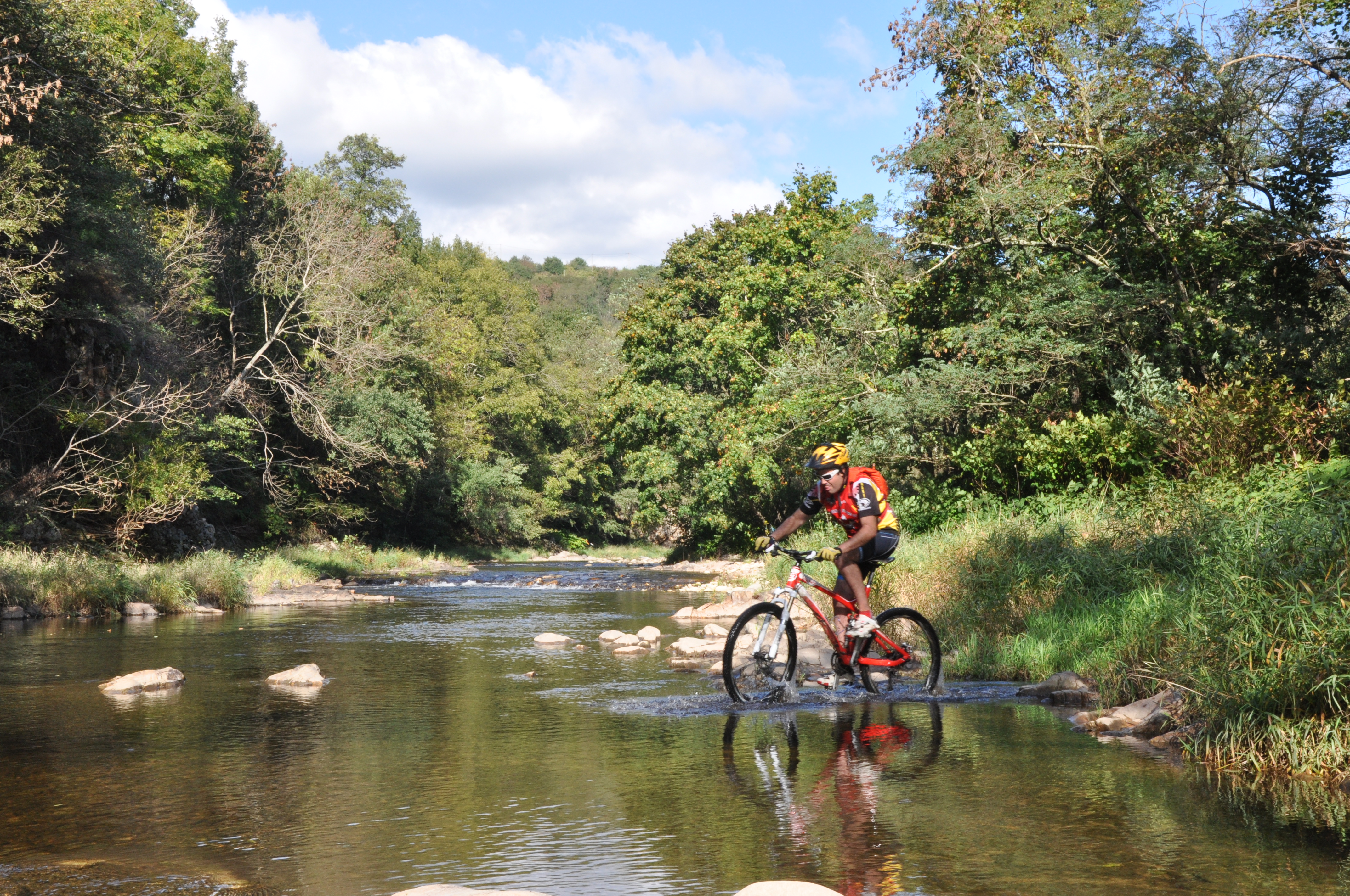
Go along the small lane passing below the public toilets. Turn second left onto the small road before bearing right when you reach les Girauds and heading down to the Vallée du Doux. The rough and rather technical track goes between orchards first then a pine forest as far as the river. Go across the shallow waters of the river. However, be careful to enquire beforehand about the water level here. Over the other side turn left and carry on along the fencing of horse pastures. Go through a rather rough section along the side of the rockface paying attention to the water level there again. Go up the steep incline round the back as far as the road running above the railway line. Head uphill on the road heading towards the village of Arlebosc.
10 - La Planta
Go along the road on the right for a few hundred metres then turn left when you reach Sarzier. Go under the lovely stone farm porch then onto the paved lane taking you back to the village.
Take the small uphill road at the end of the car park then go immediately onto the steep uphill incline passing through vineyards and orchards at the beginning.
2 – Malgaray
Turn right onto the level track. Cross the road onto a small lane leading to Jean Gros. Go past the hamlet and turn left up into vineyards. Go through the vineyards up the green slope of the dale. Just before the hamlet Morfins turn right uphill as far as Saccary where you come out of the forest.
3 – Saccary
Turn right onto the small road then the path on the left a few hundred metres further on running along the side of terraces between hamlets. At Gardon,turn right then immediately left then right again between the low walls, onto the Randocroquis trail. Turn right onto the road then left and right again onto a path going uphill into woodland that becomes wider further on. At the end, turn left into the cherry tree grove. Turn right onto the road then left between fields. To your left a narrow and sporty path takes you down into pine trees.
4 - La Garenne
Turn right onto the road then left when you get to the new houses and head down between the fields until you reach the main road. Cross the road.
5 - Sapet
Go down the small road becoming a wide track after the chicken coop. Go onto the small lane further down and continue downhill. Turn left between orchards just after Petit Chazotte.
6 - Grand Petit
Turn right between the orchards and head towards the farm les Blanchettes. After the farm turn left onto the road. At the big crossroads below take the shaded path heading towards the football pitch going along the river Doux.
7 - La Passerelle
Go over the footbridge and up the slope opposite. Cross the railway lines and head uphill into woodland as far as Tincey. Turn left onto the main road then onto the small quite steep lane to the right just after the bottom of the dale. Head uphill towards the main road going from Tournon to Lamastre. Cross over, heading towards Rattier.
8 – Rattier
Take the slightly downhill path between orchards going into a lovely chestnut tree grove. You come out onto a small road leading down to Le Crestet. Carry on along the main road going from Tournon to Lamastre and turn left down the embankment onto the road leading to the village
9 - Le Crestet
Go along the small lane passing below the public toilets. Turn second left onto the small road before bearing right when you reach les Girauds and heading down to the Vallée du Doux. The rough and rather technical track goes between orchards first then a pine forest as far as the river. Go across the shallow waters of the river. However, be careful to enquire beforehand about the water level here. Over the other side turn left and carry on along the fencing of horse pastures. Go through a rather rough section along the side of the rockface paying attention to the water level there again. Go up the steep incline round the back as far as the road running above the railway line. Head uphill on the road heading towards the village of Arlebosc.
10 - La Planta
Go along the road on the right for a few hundred metres then turn left when you reach Sarzier. Go under the lovely stone farm porch then onto the paved lane taking you back to the village.
- Departure : Arlebosc - Market square
- Arrival : Arlebosc - Market square
- Towns crossed : Arlebosc, Bozas, Boucieu-le-Roi, and Colombier-le-Jeune
Altimetric profile
Information desks

6, place du 8 mai 1945 - BP 70019, 26601 Tain l'Hermitage
Transport
Bus route N° 7 Annonay - Saint Félicien - Lamastre.
Access and parking
Follow the D234 then the D278 towards Lamastre as far as the village of Arlebosc
Parking :
Fruit market square
Accessibility
- Emergency number :
- 114
More information
Report a problem or an error
If you have found an error on this page or if you have noticed any problems during your hike, please report them to us here: