Between the Daronne and the Doux
Colombier-le-Vieux
Between the Daronne and the Doux
3h
43,8km
+1126m
-1126m
Embed this item to access it offline
8 points of interest
L'ancienne école privée - Ardèche Hermitage Tourisme 
Deyras
One of the three hamlets having given birth to the current village of Saint Victor. Even if we are not exactly on unified land here, in 1937 the « deyrasiens » (people of the hamlet of Deyras) asked for their independence which was refused. The church is one of the three bell towers of Saint Victor (born from the joining up of 3 hamlets, Saint Victor, Deyras and Navas). Its statue of the Virgin Mary dating back to 1886 is built on a plot of land belonging to a lady called Madame de l’Hermuzière who was a very important person in the history of the town of Annonay as she founded the convent belonging to the Ursulines order. Don’t miss the beautiful panorama of fruit orchards around you and the view overlooking the beginning of the river Daronne gorges.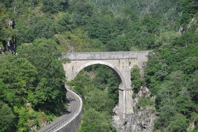
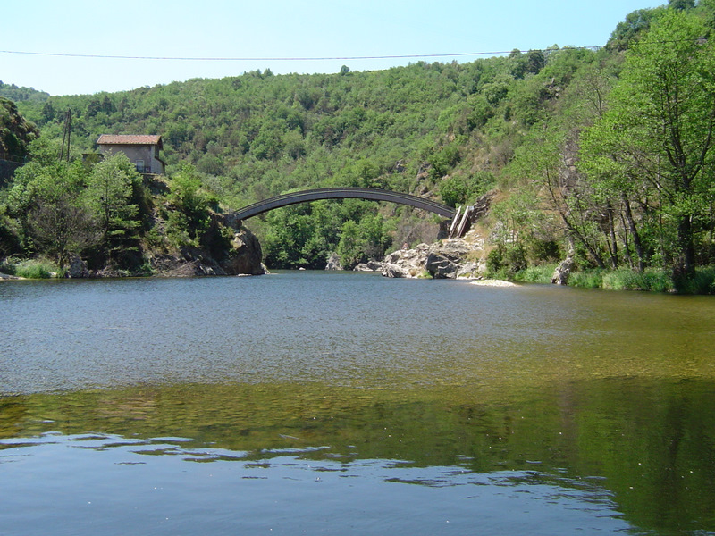
Le pont des Etroits dans les Gorges - Ardèche Hermitage Tourisme The Doux Valley a taste of Ardèche
The blue ribbon of the Doux Valley unfolds itself from the Rhône Valley to the high plateau of Saint Agrève revealing along the way three important themes divided between history, creativity and gastronomy. In Tournon sur Rhône you can almost smell the fragrance of southern France when you stroll through its picturesque narrow streets, visit its museum that seems to be standing on its own rock or discover the terraced vineyards where the legend of the well-known Côtes du Rhône Saint Joseph wine began. Lamastre, another town where you can find artist painters or sculptors going from land art to ceramics. Désaignes, classified « picturesque village » with its castle museum including the story of the Huguenots in its important menu of turbulent history during the Middle Ages. And for lovers of steam trains come and discover some spectacular landscapes aboard the Train de l’Ardèche travelling through the Doux Gorges.
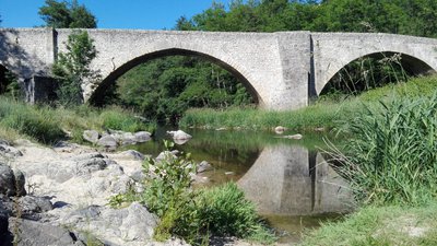
Vue d'ensemble du pont - Florence Mottet 
The King's bridge
The King’s bridge was listed amongst historical monuments in 1927. It crosses over the river Doux linking the two villages Boucieu le Roi and Colombier le Vieux. No doubt built during the XVth century, the bridge was part of the rapidly developing communication network in the North Vivarais area. It was partly rebuilt and an arch added in the XVlllth century. Where does its name come from ? The village of Boucieu le Roi had the privilege of being one of the courts of justice installed by Philippe le Bel at the end of the XVlllth century. At that time the kings of France seeked to establish their power in the provinces by forming alliances with the local lords. The village of Boucieu was founded and its inhabitants became exempt of taxes (except for the salt tax). Unfortunately it did not last for ever, a disappointment for people living there today.The château of Chazotte
Its oppressing building (XVllth century) overlooking the river Doux valley, towers to the east of the village of Arlebosc. It is characterized by 4 « culs de lampe » towers along with its highest, more recent tower on the west side.Arlebosc
Traces of the history of Arlebosc can be found in the legend of Saint Just the bishop of Lyon who converted the people of the town to Christianity in the lVth century. The village developed with fortified manor houses such as the Malgary, Romaneaux châteaus, not forgetting Chazotte château overlooking the railway line. It is even said that its shutters remained closed until the railway line reopened. Needless to say, the marquis of Arlebosc was also the town’s first mayor and to this day still shares his passion for his village. Come to Ardèche Hermitage tourist office and find the “hidden archives of Arlebosc” treasure map to take you on a journey through time and space discovering all there is to know about the history of this old priory.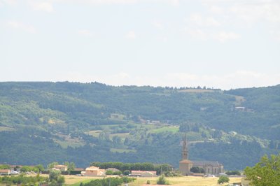
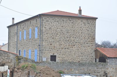
Village de Colombier le Vieux - Ardèche Hermitage Tourisme Colombier le Vieux
Bordered by the Daronne and Doux rivers’ gorges the village of Comombier le Vieux dominates the surrounding landscape. Other than its undeniable nature heritage, you will also find beautiful traces of lordship architecture dating back to XVlth century with the château de Bellecombe recently restored aliong with the fortified manor house of Ruissas. Colombier le Vieux was used to illustrate the book La Maison Rouge by Maurice Genevoix. The latter tells how the village was passed to the Huguenots and targeted by a troop paid by the catholics. A book to enjoy reading.
Description
At the end of the main street, in front of the restaurant, leave the main road and turn left onto the small road signed up Chardon, Palisse, La Freydière and Couix continue for 150m then left again towards La Daronne.
1. 1,1 km Continue on the road, past Plaisance, down to the river Daronne, cross then go up towards the village passing Mentelin on the way.
2. 3,9 km In Deyras turn left at the yellow postbox.
3. 5,4 km At the junction on the main road turn right, then first right onto a small road towards “lac de Jointine” and Etables.
4. 7,8 km At the stop sign go straight on then left when you come to the second stop sign as you go past “place de la liberté.
5. 8,8 km Leave the village and turn first right signed up Morens.
6. 9,8 km Go straight on past the hamlets Four and Marzillac.
7. 11,9 km Just before entering Morens turn first left onto the small road then first right past the village signed up Malapos and Le Doux. The road takes you down to the edge of both rivers Doux and Daronne where they meet up.
8. 16,9 km At the crossroads opposite the wooden cross, turn left towards Vers CD534.
9. 17,9 km Go down to the road and continue to the left towards Tournon-sur-Rhône.
10. 20,9 km At the junction between the D234 and the D534, turn right signed up Lamastre, Colombier-le-Jeune and St-Barthélémy-le-Plain.
11. 28,4 km At the crossroads between the D534 and the D209 turn right and continue to Boucieu-le-Roi.
12. 32 km Follow the signs to Arlebosc.
13. 36,2 km At the crossroads as you enter the village follow the signs to St-Félicien.
14. 39,1 km At the crossroads where the D578 and D272a join up turn right onto the small road signed up Les Champs, Petit Réaux, Réaux, Prade, Veyrand and La Planta then continue 800m, turn right again onto the small road as you enter Veyrand and follow the signs to Chalieu.
15. 40,6 km Turn first left signed up “Gîte Saint-Gris” and go past the village of the same name.
16. 42,2 km At the crossroads “Ruissas”, follow the small road on the left then turn first right. Go down the road, past the hamlet “Miallier”, cross the stream then uphill to Colombier-le-Vieux past Côte-Rotie.
- Departure : Colombier le Vieux – Undercover market square
- Arrival : Colombier le Vieux – Undercover market square
- Towns crossed : Colombier-le-Vieux, Saint-Victor, Étables, Saint-Barthélemy-le-Plain, Boucieu-le-Roi, Bozas, and Arlebosc
Altimetric profile
Information desks

6, place du 8 mai 1945 - BP 70019, 26601 Tain l'Hermitage
Access and parking
Parking :
Undercover market square
More information
Report a problem or an error
If you have found an error on this page or if you have noticed any problems during your hike, please report them to us here: