Lalouvesc - Tournon sur Rhône difficult
Lalouvesc
Lalouvesc - Tournon sur Rhône difficult
Hard
5h
42,4km
+936m
-1904m
Embed this item to access it offline
8 points of interest
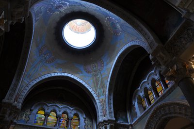
Choeur de la basilique - Ardèche Hermitage Tourisme 
Saint Régis in Lalouvesc
Reviving catholic faith in people from the hilly regions of Vivarais, Velay and Cevennes was the mission given to Saint Jean François Régis ! Ordained as a priest in 1630 and a missionary in 1632, this tireless walker used to cover 40 to 60 kilometres of ground every day. On 23rd December 1640, in a snowstorm, he left for what was to be his last mission in the North of the Vivarais region. He fell ill on the way and in spite of his high fever, he continued to pray and hear confession up to his last breath. On 31st December 1640 « God’s pilgrim » died in Lalouvesc at the age of 43. He received beatification in 1716 from the Pope Clément Xl and was canonized later on in 1737. Following that, Lalouvesc became a place of pilgrimage and a basilica was built in his name. Its building took 12 years to finish. The Basilica has two belltowers taken from two old churches. The final basilica was consecrated on 5th August 1877 by cardinal Guibert who was archbishop of Paris. The religious building houses relicas of the Saint and the stained glass windows present a visual review of his life. On the occasion of big events the tenor bell rings and can be heard for kilometres around. Information source : Topoguide "Le Chemin de Saint Régis" du Puy en Velay à Lalouvesc
 Small patrimony
The cross of Montplot
Joannès Dufaud (parlarem en Vivarés edition 2004) describes it as a mountain of timber and wood stumps or quite simply a mountain where trees are logged and cut into ¾-metre lengths as in a wood yard. We can in fact observe here, that the way of working hasn’t changed much over the years. Information source : Ardèche Sports Nature.- Small patrimony
The terraces
In this area "Chalets" is the word used to describe terraces on slopes making them useable for various cultures. Most of the terraces were built in XVlllth and XlXth centuries. At that time, the population, 90% of which were farmers, was on an increase. Always looking for land to cultivate, quite simply to survive, the latter were forced to use the steep slopes. Vine growing was also on an increase during that same period and necessitated arable land. Building terraces was the answer; increasing surfaces for growing and at the same time making the slopes easier to use, enabling water retention and controlling it, keeping the soil from erosion and restoring the heat absorbed by the rock-stone during the day. Little by little the use of these "chalets" was abandoned due to various plant diseases at the end of the XlXth century, particularly Mildew and Phylloxera that destroyed whole vineyards and crippled farming. However, rural depopulation, the number of lives lost during the first World War and the mechanization of farming down in the lower plains were the main reasons for terraces being abandoned. As you stroll along you will discover a landscape shaped by these « farmer builders”. Here, amongst this stone architecture, traces are particularly visible, making it easy to imagine the magnitude of the task.  Panorama
Viewing point
Occasional view of the Doux gorges and a few old terraces some of them which are still looked after today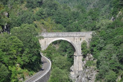
Pont des Etroits - Ardèche Hermitage Tourisme  Flora
FloraThe Doux Gorges
The path finds its narrow way through dug out rocks downstream from the village of Boucieu le Roi. Very often it runs directly upon the rock along the narrow river gorges between sheer cliffs. Some parts can only be accessed via the train running along the valley floor. The arid character of these rocky surfaces, linked with the climate of the Rhône Valley, make for a strong mediterranean influence concerning the fauna and flora in the area. Green and white bark oaks, along with broom bush and heather moors now cover the steep slopes in places where, in time gone by, animals used to graze or they were used for various cultures. Amongst the fauna living in this rocky climate are different reptiles : the green and yellow grass snake is very common, the endemic southern smooth snake along with wall lizards Some crags are ideal nesting places for the very rare eagle owl. Information source : SIVU Doux Clair, Conservatoire Rhône Alpes des Espaces Naurels, la Vallée du Doux, un voyage aux multiples ambiances, Natural Heritage guide of the Rhône Alpes region, 1995.Hydroelectric plant of Mordane
During the first world war the French government decided to considerably increase the production of electric energy. A new water impoundment was built in order to supply a hydroelectric plant situated downstream from the existing site of Mordane. In order to link the two structures together a company « Société des Forces Motrices du Vercors » led the project of building a 2-kilometre long canal along the river Doux gorges between 1917 and 1920. Part of the work was done by German war prisoners giving it its name « canal of the Germans » It was taken over by the EDF company in 1946 and is still working today with an average yearly production of 11GWh.Grand Pont
The building of this majestic bridge called the « Grand Pont », began around year 1380. Its construction was by no means easy ; the scaffolding was regularly carried away by floods of the river Doux lower down which is one of the reasons why a semi-arched architecture was chosen. Classified amongst historical monuments in 1954 the bridge has become part of everyday life for the local people who show a certain devotion towards it.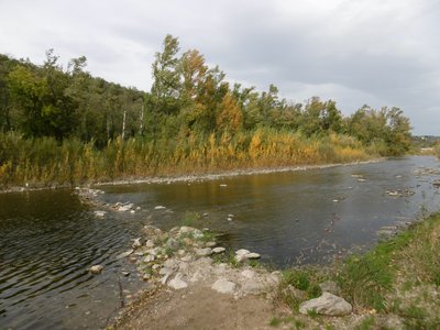
Ripisylve du Doux - ADSEA FloraThe riperian woodland
As you stroll along the river Doux perhaps you will notice the forest fringe, occasionally just a row of single trees, covering the best part of the banks. Its name in French is "la ripisylve" or in English « Riparian woodland”. It holds an important role for the river ecologically speaking. The tiny aquatic fauna find their food there, it helps fish to hide from predators amongst the roots and it also supports the river banks and avoids erosion of the latter. In addition, it hems in polluting elements such as nitrates and regulates brightness. Its regular maintenance benefits most kinds of fish. Alder, willow, ash and poplar trees are the most common trees to be found there. The black locust similar to an acacia and the Japanese knotweed are, for their part, not welcome and are increasingly taking over the banks impoverishing this original ecosystem. Information source : SIVU Doux Clair, Conservatoire Rhône Alpes des Espaces Naturels, La Vallée du Doux, un voyage aux multiples ambiances, Guide du patrimoine naturel de la région Rhône Alpes, 1995. Available in the tourist offices of the Doux Valley.
Description
1 - Lalouvesc - Follow N°101 Red.
Go down the main road towards Satillieu and take the first path on the right near the village water treatment plant.
2 - Le Bois Noir – Follow N°101 Red.
Continue on the track entering into the forest. On a right bend don’t miss the narrow path to the right going down in between pine trees. Follow the trail markings passing through a succession of crossroads. You come out onto a wider track. Go along the track for a few metres before turning sharp right onto a path through woodland. Further down you will come to a track taking you across the dale and a little way up the other side.
3 - Combe – Follow N°101 Red
Stay on the track going past a farm pasture and bee hives. In the middle of the field bear sharp right onto the uphill slope. Go onto the downhill path as you come out of the field and down into another dale. Continue over to the other side.
4 - Le Buisson – Follow N°101 Red
Go out of the hamlet on the road leading to it then onto the road going downhill on the right. Bear right immediately, go through the gate and onto the path becoming steeper as you go along.
5 – Col du Marchand – Follow N°100 Blue
Cross the main road onto a pleasant forest route going slightly uphill. Further on you will come across another rough and technical section.
6 - Pourchat – Follow N°102 Blue
Continue ahead on the level forest route on the left.
7 - La Côte de Bruchet - Follow N°103 Red
Leave the forest route for the incline taking you up to the ridge over some quite rough sections then onto a more easy-going forest track between beech trees. The slope down the other side is sporty and enjoyable.
8 - Croix de Lyonnet - Follow N°103 Red
Go right onto the wide track skirting the dale. When you reach the hamlet turn right onto a grass path leading into woodland which becomes quite rough towards the end.
9 - Bois de Meyannes - Follow N°102 Blue
Carry on along the same track towards Col du Juvenet to finish off the downhill incline. Cross the main road and head up towards Montplot on the steep incline.
10 - Montplot - Follow N°102 Blue
Turn left onto the path when you see the pretty stone hamlet facing you then bear right at the first fork. Continue on the easy-going track that becomes a road over the other side which is the start of the downhill run towards Saint Victor.
11 - Gounon - Follow N°102 Blue
At the T junction turn right onto the road.
12 - Les Bauds - Follow N°102 Blue
Bear sharp left onto the windy path, with gates all the way along and quite technical towards the end. Go into the village.
13 - Saint Victor - Follow N°102 Blue
From the village square go through the narrow alleys leading onto the road towards Corsas. When you get to la Croix des Rameaux, bear left down into orchards. A little further down you come to a hamlet. Head towards the road to avoid going through. At the following crossroads turn left onto the road going downhill. In the middle of some fields take the grass path leading into the woods and carry on through.
14 - Laumache - Follow N°102 Blue
Turn right onto the small road as far as the hamlet.
15 - Corsas – Follow N°102 Blue
At the crossroads 4 routes turn left through the hamlet between the château and its farmyard. Cross the main road and continue the small road facing you towards Etables. A steep uphill climb awaits you near the Lac de Jointine. Go through the Sylvester pine woods then onto a country path straight ahead. It takes you to the other side of the village.
16 - Etables - Follow N°102 Blue
Leave the village on the D229.
17 - La Chapelle Bosc - Follow N°105 Red
Continue ahead on the main road for a few metres then right onto the route de Morens.
18 - Bois de Verne - Follow N°105 Red
Carry on ahead on the road then bear left towards Domaine du Moulin. The road becomes a track and plunges down into the dale before heading back up the other side where it becomes steep and rough. At the top on the plateau go onto the wide track facing you. Go onto the small lane leading to the main road. After a few hundred metres along the main road turn right onto another road.
19 - Les Grands Bois - Follow N°105 Red
Continue ahead along the lane.
20 - Les Terres Grasses - Follow N°105 Red
Take the steep incline on the right down to heath-like ground. Go along the windy path overlooking the Gorges du Doux, before going back up a pretty steep slope towards Gouny and Monerone. Go back onto the interesting GR trail heading down to the where the gorges come out. The downhill incline finishes on a small road taking you to the lovely bridge over the river Doux.
21 - Le Grand Pont – Follow N°105 Red
Go over the bridge onto the main road and head towards Tournon. At the restaurant turn left then left again going round the campsite. Zigzag along the single track running parallel to the river Doux joining the dam further on.
22 - Rochebonne – Follow N°105 Red
Continue along the dam following the river until you reach the bridge.
23 - Pont du Doux
Head towards the town of Tournon on the ViaRhôna cycling track.
- Departure : Lalouvesc - Lake square
- Arrival : Tournon-sur-Rhône - Rue Pasteur
- Towns crossed : Lalouvesc, Vaudevant, Saint-Victor, Étables, Lemps, Saint-Jean-de-Muzols, and Tournon-sur-Rhône
Altimetric profile
Information desks

6, place du 8 mai 1945 - BP 70019, 26601 Tain l'Hermitage
Transport
Bus route N° 11 Tournon sur Rhône - Saint Félicien - Lalouvesc equipped with bike-rack during the summer season. .
Access and parking
Follow the D532 from Saint Félicien to Lalouvesc.
Parking :
Lake square
Accessibility
- Emergency number :
- 114
More information
Report a problem or an error
If you have found an error on this page or if you have noticed any problems during your hike, please report them to us here: