Moulin des Gaillards
Vaudevant
Moulin des Gaillards
Hard
2h
18km
+651m
-656m
Embed this item to access it offline
6 points of interest

 Small patrimony
Stone Masks
As you go past the church in Vaudevant glance at the apse to see its joyful little devil pulling his tongue out, seeming to make fun of you. Other enigmatic masks of this kind decorate walls of houses in the village and the whole of the area around Saint Félicien. Very often you find them on the outer walls of churches, on rich dwellings, on mission crosses or simply on walls of homes in the country villages. Of all ages and forms their presence remains rather mysterious and leads to various explanations…… even the most far-fetched ones. For fun, whimsical ideas of stone cutters, religious beliefs and superstitions dating back to our celt ancestors, symbols of protection… What do these human faces truly represent, peering at us with such distinctive expressions? Why not just let your imagination run riot. Information source : Le chemin des masques, région de Saint Félicien, association Histoire et Patrimoine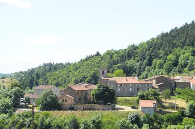
Vue d'ensemble du village - Ardèche Hermitage Tourisme 
Vaudevant
Mention of the village was already found during the Xlllth century. Its name would originate from « Val des Vents », « les Avents » (referring to wind) being a small hamlet situated at the top of the village. In 1090, the village became part of the town of St Félicien and joined the canons of St Barnard chapter (Romans sur Isère). However, following long negociations the village regained its autonomy in 1790.
Montée du Moulin des Gaillards - Ardèche Hermitage Tourisme  Panorama
Viewing point
An enhancing landscape gradually comes into view revealing the Daronne valley and the old bridge down below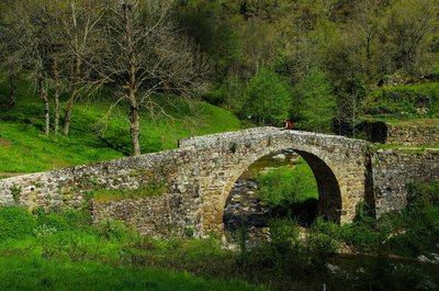
Pont au niveau du moulin - David Genestal - Carnet de Rando 
Gaillards Mill
Excellent evidence of how the Haut Vivarais is a geographically scattered housing region. Nature’s resources of have always been used in this area. The lack of wind forced people to use water. Water mills enabled the development of the earliest industries where wood was cut and grain and chestnuts were ground. Also called the bread tree, the chestnut tree prevented the county of Ardèche from famine on many occasions due to the high content in protein of its fruit. It is said that the life of the people of Ardèche is closely linked to that of the chestnut tree in many ways. Babies were rocked in cradles made from chestnut wood, chestnut leaves were used to feed cattle when fodder was lacking, its fruit was a main food, its wood was used for burning and people were buried in chestnut coffins. Quite a lovely story don’t you think ?- Panorama
Viewing point
Viewing point overlooking the meandering Doux river. - Panorama
Viewing point
Splendid view of the Daronne Valley
Description
1 – Vaudevant
Go up to the church then onto the street opposite the entrance. At the end of the straight stretch of road turn left up the path through pastures and woodland.
2 – Char
Take the small lane on the left.
3 – Brudon
Turn left when you see the old cart axle, onto the narrow path taking you down through fields. Go through the hamlet then carry on down to the main road.
4 – Sauze
Turn right and go along for a few metres before turning left and heading down towards the first house. Go along the road below, running parallel. Cross the road and continue along a grass path going uphill. When you come out onto the small lane, carry on along until you reach the end. Continue along the path then turn left at the first crossroads onto a rough and technical path. Further down go onto the road leading to houses.
5 - La Simonde
Bear sharp right onto the very steep lane.
6 - Chemin de la Congerie
Continue on the even steeper rough path facing you. Further up bear left down into pine woods. Cross the main road further down onto the lane which becomes track as it goes through the residential area.
7 – Chatelas
Head down the grass path to the left. Turn left onto the main road below and go along a few metres before turning right onto the lane leading to Goudard. Go past the farm barn on the small path and back onto another road further on going down to Moulin des Gaillards.
8 - Moulin des Gaillards
Go along the paved path on the right along the building. Further up, go through the hamlet and turn left. Bear left at the T junction (postbox) then left again onto a grass path just before the first house. The path zigzags down through woodland to les Gaillards. Just before the road, bear sharp right and carry on down. Cross the stream then continue through woodland along the hillside, parallel to the river Daronne until you reach the following hamlet.
9 – Raillon
Take the road leading to the hamlet and head down towards the campsite below on the edge of the river.
10 – Pierrageai
Just after the shallow water crossing follow the river along the leisure area of the campsite. The path continues through the tree gardens then zigzags through woodland.
11 – Brintenas
Go onto the road facing you leading to the top of the campsite. At the following crossroads take the road on the right. When you reach the top bear right onto the track going up into the woods. This leads to another road where you turn right then right again onto the upper road. When you reach the cross, turn left onto a rough and technical section.
12 – Montpeyroux
Continue ahead on the road leading to Col de Fontaille. Cross the main road onto the lane further down, to the left of the house opposite you. Go down into the residential area keeping to the left. The road becomes a country lane along the hillside. Head down into the dale, cross the river Vivance and go up and along the other side taking you back to the starting point.
- Departure : Vaudevant - Centre of the village
- Arrival : Vaudevant - Centre of the village
- Towns crossed : Vaudevant, Saint-Félicien, and Saint-Victor
Altimetric profile
Information desks

6, place du 8 mai 1945 - BP 70019, 26601 Tain l'Hermitage
Access and parking
Follow the D115 from Saint Félicien to Vaudevent
Parking :
Centre of the village
Accessibility
- Emergency number :
- 114
More information
Report a problem or an error
If you have found an error on this page or if you have noticed any problems during your hike, please report them to us here: