River Herbasse and its tributaries

Charmes-sur-l'Herbasse
River Herbasse and its tributaries
Medium
3h30
36,5km
+537m
-549m
Embed this item to access it offline
1 point of interest

Château de Charmes - Ardèche Hermitage Tourisme 
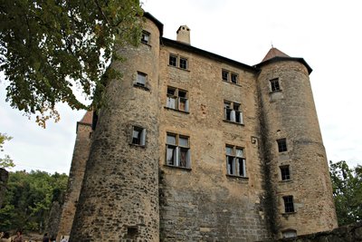
The feudal château of Charmes
In its strategic position overlooking the valley of Herbasse, the château de Charmes was built by the Lords of Nerpol whose arms can still be seen to this day on the southern side. With its 2-metre thick walls, sunken several metres into the ground, the structure has hardly been altered since Xlth century. In the XVth century Imbert de Bathernay became the friend and advisor to the dauphin, the future Louis Xl. In the beginning he was his faithful hunting companion and over the years became one of the king’s most important advisors. A crafty and unscrupulous man, he was at the heart of several royal intrigues for which he was rewarded with lots of land and castles making him a man of great fortune.
Description
Go to Bathernay.
1. 4,3 km
In the village turn right onto the D584 “route d’Hauterives”.
2. 6,8 km
Follow the sign Montchenu to the village.
3. 10,1 km
Go through the village and turn right onto “route du grand chemin” signed up La Bomme.
4. 10,9 km
On the right “chemin Saint-Michel” (ignore “l’impasse des galets”).
5. 12,5 km
Turn left onto “route des Ferlets”.
6. 14,1 km
Turn right “route de St-Mury”.
7. 15,2 km
Turn right “route du château”.
8. 17,9 km
Turn left after the 2nd hairpin bend “rue des Grandvers”.
9. 18,4 km
At the roundabout turn left onto the D67 signed up Crépol.
10. 20,3 km
Turn left onto the D538 signed up Beaurepaire.
11. 22,7 km
Turn right onto the “route de la Limone”.
12. 23,1 km
Turn right onto “chemin de Mathurin”.
13. 23,7 km
Do not turn right onto “chemin de Saint-Mury”.
14. 24,1 km
Turn right onto “route de Bourdogne”.
15. 25,4 km
Turn right onto the main road.
16. 26,4 km
Turn left and continue to Margès.
17. 28,2 km
On entering Margès follow signs for St-Donat.
18. 33,5 km
Before entering the town turn right onto the D67 to Charmes.
- Departure : Charmes sur l’Herbasse – Centre of the village
- Arrival : Charmes sur l’Herbasse – Centre of the village
- Towns crossed : Charmes-sur-l'Herbasse, Bathernay, Montchenu, Margès, and Saint-Donat-sur-l'Herbasse
Altimetric profile
Information desks
6, place du 8 mai 1945 - BP 70019, 26601 Tain l'Hermitage
Access and parking
Parking :
Centre of the village
Report a problem or an error
If you have found an error on this page or if you have noticed any problems during your hike, please report them to us here:

