The heights of Mercurol
Mercurol-Veaunes
The heights of Mercurol
Easy
3h
8,5km
+257m
-258m
Embed this item to access it offline
5 points of interest


Saint Anne church
Built first in 1520 in a pure Roman style, a large part was rebuilt in 1820 in a « neo-romanesque » style. In the Catholic tradition, Saint Anne is the mother of Mary.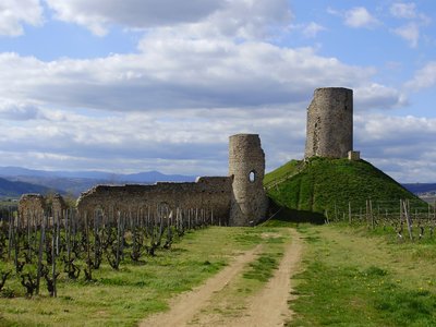
Vue d'ensemble de la tour - Ardèche Hermitage Tourisme Mercurol watchtower and its heritage
The main activity of the village of Mercurol is agriculture through its renowned vineyards of Crozes Hermitage. The village was certified as belonging to the fiefdom of the Lord of Mercurol as from 1064. It offers a beautiful view over the Rhône Valley and Vercors mountain range. A watchtower and remains of a feudal castle stand high at the top of the hillside. They once belonged to the Baron of Clérieux. Over the centuries the tower and its castle have been handed down from generation to generation and have suffered various bad times : the plague, the Revolution…. The circular tower standing on the peak is currently partly in ruins . The village below has developed over the years.The château of Conflans
This old fortified manor house, built by Jean de Conflans in XVth century is a reminder of a traditional type of construction that lasted until the beginning of XVllth century in our region. These fortified manor houses are neither castles nor ordinary houses. They are somewhere between the two. Often built by the families of important local Lords and situated along the main axes near to main crossroads or on the edge of a fiefdom. The extension of fortifications to the houses (turrets, palisades, moats…) was by no means an easy task as the lord had to give his assent ! Small patrimony
Mont Laurent telegraph aerial
The « Chappe » telegraph aerial was erected at the top of the Mont Laurent and can be seen on the land register dating back to Napoleon’s time. The system enabled long-distance communication and was made up of a structure on high ground with a mast and two articulated indicators. The position of each of the indicators represented a number. With a code manual the operator could therefore decipher the message. Flora
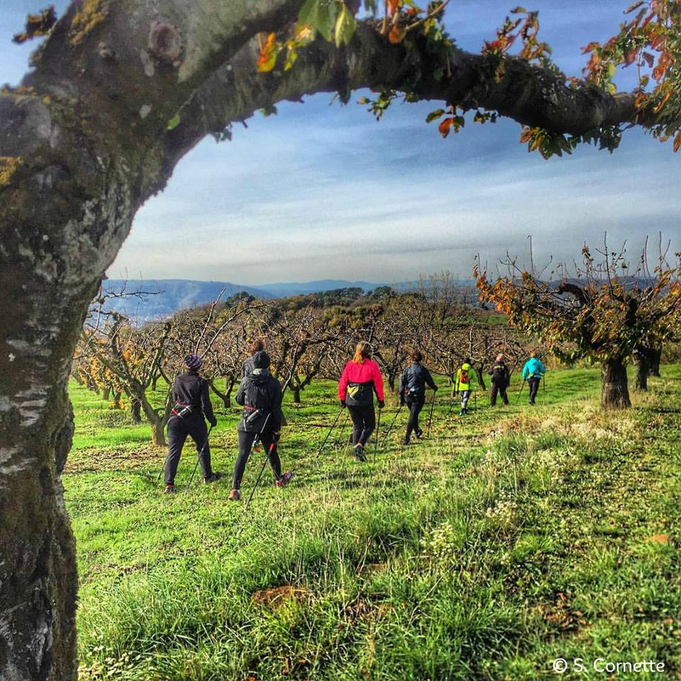
FloraOrchards and vineyards
Traces of Mercurol wines can be found in the archives of France’s great national library. A publication dating back to 1861 refers to the latter like this : “ Mercurol white wines are remarkable through their delicacy, freshness and distinctive strong and pleasant aromas. In its best years, it compares well with many well appreciated wines of its category due to its soft and rich qualities. It can be layed down for over 15 years with no alteration”. Not only vines enjoy the light soils of this small town; fruit trees also contribute to the Rhône Valley being considered one of the best orchard regions in France.
Description
Head up to the church.
1 - Eglise - 200 m
Go up to the watchtower then towards the hillside les Pends. Go along the edge of the plateau (ignoring the paths on your left) and along vineyards, part of the Mercurol terroir carrying the Crozes Hermitage appellation. Go under the high-voltage cable then to the left of a reservoir. Turn right and go downhill. When you get to the road turn left along the wall of the château de Conflans. Turn right to the cemetery.
2 - Conflans - 180 m
Follow the road to the left after the cemetery for 250m. When you get to the hamlet Maubet bear right then, at the end of the road, go right up a grass path. You come out onto a path cutting across.
3 - Bredoux 237 m
Turn left onto the path and when you get to the end follow the small lane on your left taking you to the cemetery.
4 - Veaunes cemetery - 250 m
Turn left here
5 - Veaunes - 247 m
Turn left again onto the D115 and after 300m on the bend, turn right onto the chemin de Taillas heading uphill to the right.
6 - Marion - 260 m
When you get to a section through undergrowth and levelling off at the crossroads Marion, take the path on the left. Go alongside vineyards.
7 - Champ du Mas - 228 m
When you come out of the woods continue ahead until you reach the road. Go down to the D115 (190m). Turn right then left onto route de la Baume. On the bend turn right onto a path through undergrowth then along the road leading back to the village of Mercurol.
- Departure : Mercurol-Veaunes - Large car park at the bottom of the village
- Arrival : Mercurol-Veaunes - Large car park at the bottom of the village
- Towns crossed : Mercurol-Veaunes and Chanos-Curson
Altimetric profile
Information desks

6, place du 8 mai 1945 - BP 70019, 26601 Tain l'Hermitage
Transport
Bus route N° 10 Romans sur Isère - Tain l'Hermitage - Tournon sur Rhône
Access and parking
Follow the D115 from Tain l'Hermitageto Mercurol
Parking :
Large car park at the bottom of the village
More information
Report a problem or an error
If you have found an error on this page or if you have noticed any problems during your hike, please report them to us here: