The châteaux route
Arlebosc
The châteaux route
Medium
4h30
11,8km
+442m
-441m
Embed this item to access it offline
7 points of interest
Vue extérieure du château - Ardèche Hermitage Tourisme 
The château of arlebosc
In the centre of the village you can see the old medieval château no doubt dating back to Xlllth century. Destroyed and in ruins it was rebuilt or made bigger several times and is a definite characteristic evidence of the past.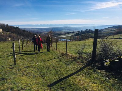
Point de vue sur les Alpes - Ardèche Hermitage Tourisme  Panorama
Viewing point
Beautiful views of the French Alps.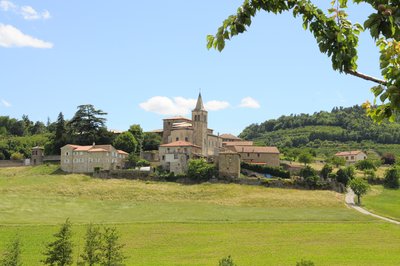
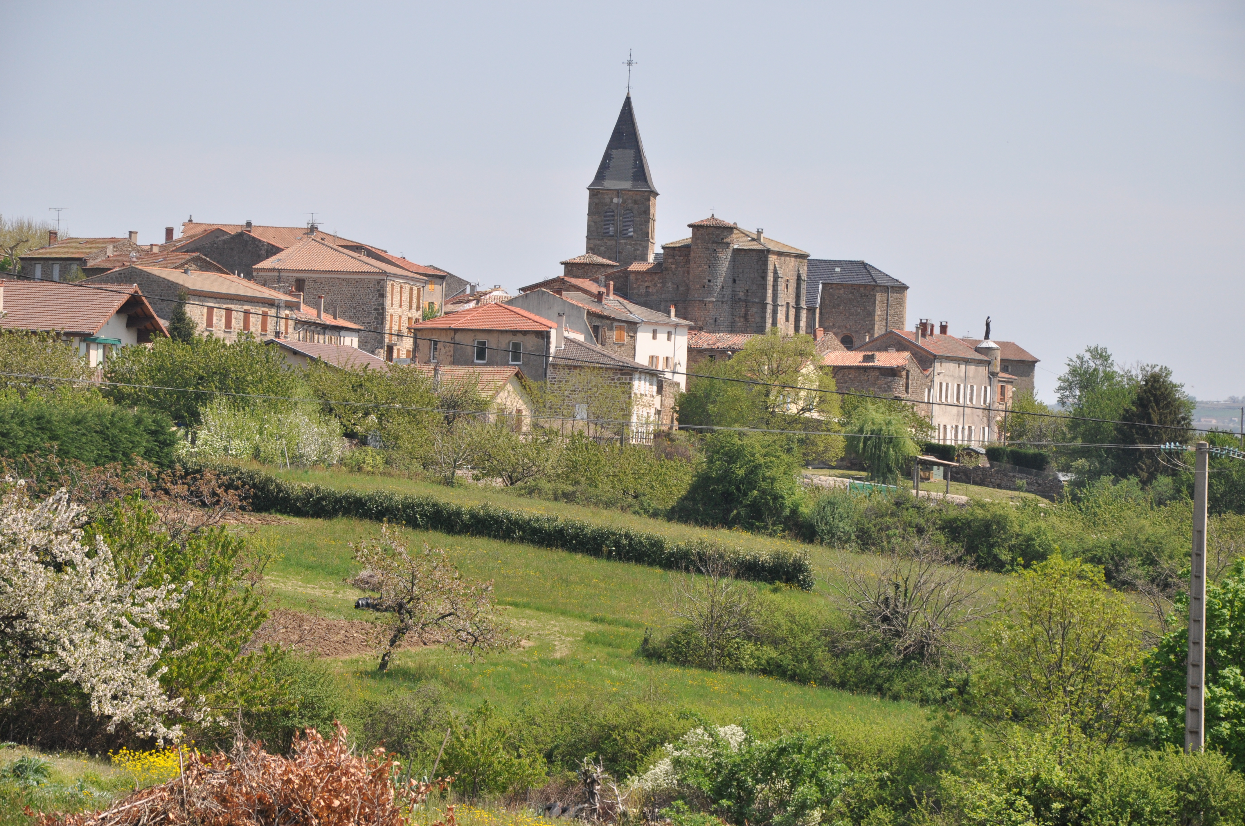
Vue du village - Ardèche Hermitage Tourisme 
Bozas
On the high plateau of Ardèche, Bozas is a lovely village full of treasures to discover. Several theories exist concerning the origin of its name. Some say it has an Occitan origin « bosa » meaning « a round shape » or perhaps « bos » meaning « wooded area » however the most likely origin would come from the first family owners of the village whose name was Boson. The first evidence of the château dates back to the Xllth century even though the remaining parts, to be seen nowadays, date back to the XVth century. There was also a small priory of the Cluny order from the Xlllth century. As well as its rich history the village offers magnificent landscapes including a view of the Mont Blanc in the distance, on a clear day. Don’t miss here the “rando croquis” walk where the whole family can enjoy the beautiful countryside round Bozas and learn some techniques for making it into a picture. So get your sketching pads and pencils ready…. !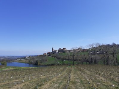
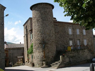
Village avec le château en son sein - ADSEA The château of Bozas
This château is made of " three wings arranged round a small inner courtyard, closed from the east side by a wall with a postern cutting through it " It was built between Xlllth and XVth century no doubt. At the end of the XVlllth century the village Marquis had an important extension added on.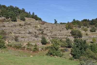
Vue des chalets - Ardèche Hermitage Tourisme  Small patrimony
Chalets
If ever you hear a native of Ardèche mention the words « chalets », « faisses » or even « chambas » he (she) isn’t talking about the names of birds, just describing the so familiar landscape ! It definitely isn’t an easy task being a farmer on such steep slopes but it takes more than that to discourage the people from round here. And that is how Mankind came to shape the landscape making it more possible to work on. In order to increase the amount of land for growing, he decided to build the dry-stone wall terraces you can see, spreading across the slopes. These retaining walls were also used to hold water tanks, very handy on granitic well-drained soils ! Panorama
Viewing point
Viewing point overlooking the village of Bozas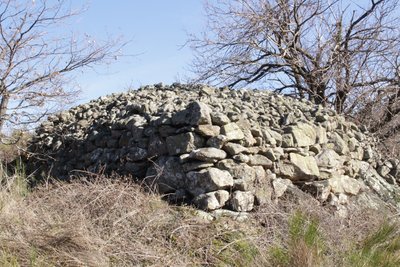
Chirat bâti par les paysans - Ardèche Hermitage Tourisme Small patrimonyFarmer builders
At the hamlet called Les Morfins you can see how stone is a predominance in this landscape shaped by agriculture. The heaps of stones called "Clapas" or more locally "Chirat" didn’t come from the album, with a marked Irish influence, « Marchand de Cailloux » by the French singer Renaud , they were quite simply stones piled up by farmers on the edge of fields after being dug out for other uses and also to make the land more easy to work on. They are living proof of a rural civilisation that “tamed” water and stone and add to a stone architecture that the decline of agriculture has somehow made us forget. We cannot remain indifferent to the labour of these « farmer builders » who stone after stone built terraces or « chalets ». And there efforts did not stop there as they also built walls, enclosures to protect vegetable plots, small outbuildings, wells and other fountain vaults, steps, huts…. “graveliers » is the name they gave to small huts made of drystone, covered with vine shoots and used to shelter farmers and for storing tools and crops. Information source : "Paysans bâtisseurs, paysages de pierres, paysages de vie", association Histoire et Patrimoine, 2001.
Description
The walk starts at the « Info rando » information board. Cross the square and go down the steps to the main street.
1 - Arlebosc - 423 m Follow La Passerelle 2 km Boucieu le Roi 5 km
Go down the little street then, at the cross, onto a path facing you, leading to the Château de Chazotte. After about 200m leave the main path behind you and turn right down into the woods, on a narrow, walled, rough track which leads to another small lane. Once on the lane, take the first path on the left taking you down to the river Doux.
2 - La Passerelle - 280 m Follow Boucieu le Roi 3 km
The path goes alongside the river then turns off towards the road. Immediately after crossing the bridge, turn left uphill. When you reach the farm turn left onto the path running alongside the farm buildings then orchards.
3 - Grand Petit - 320m Follow Bozas 3.2 km
Go up into the orchard. Once on the road turn right then first right onto a track taking you to Sapet.
4 - Sapet - 470 m - Follow Bozas 1.3 km
Carefully cross the main road and go up the track facing you.
5 - La Garenne - 538 m - Follow Bozas 300 m
Go through the hamlet la Garenne to the small road taking you to the village of Bozas.
6- Bozas - 530 m - Follow Malaurier 2 km Saint Félicien 6,3 km
Go down the small lane
7 - Bozas - 541 m - Follow La Combe 800 m Arlebosc 5.3 km
Cross the stream.
8 - Ruisseau de Choisine - 530 m - Follow Malaurier 1.5 km Saint Félicien 5.8 km
Go up a pleasant track taking you to a small road at La Combe.
9 - La Combe - 590 m - Follow Malgaray 3.7 km Arlebosc 4.5 km
Follow the small road to the left then turn right when you get to the hamlet Gardon onto a low-walled track. Go through another hamlet then follow the small uphill lane.
10 - Saccary - 630 m - Follow Malgaray 2.1 km Arlebosc 2.9 km
Go uphill a little then turn sharp right and go down to Les Morfins. Turn left just before the hamlet taking you over to the other side of the dale. When you come to an orchard go down the side then turn left to cross through it. Go below the house Jean Gros and follow the road. After the hamlet, at the crossroads, take the track facing you.
11- Malgaray - 473 m - Follow Arlebosc 800m
Continue ahead downhill through orchards taking you back to the main square in Arlebosc.
- Departure : Arlebosc -Fruit market square
- Arrival : Arlebosc -Fruit market square
- Towns crossed : Arlebosc and Bozas
Altimetric profile
Transport
Bus route N° 7 Annonay - Saint Félicien - Lamastre.https://www.auvergnerhonealpes.fr/286-ardeche.htm
Access and parking
Follow the D234 then the D278 towards Lamastre to the village of Arlebosc
Parking :
Fruit market square
More information
Report a problem or an error
If you have found an error on this page or if you have noticed any problems during your hike, please report them to us here: